What it is
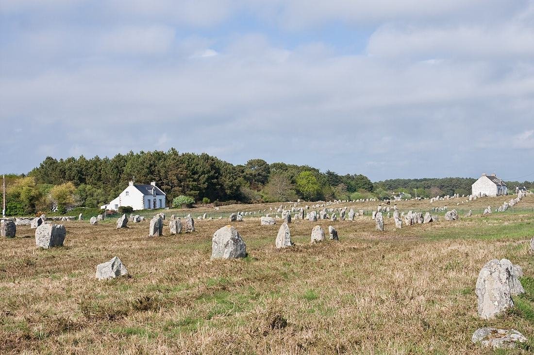
Carnac is a small town on the south coast of Brittany, in the French department of Morbihan. Around it stands the largest group of standing stones on Earth: more than 3,000 menhirs cut from local granite. Most are lined up in long parallel rows that run for more than a kilometer across heath and farmland. Tombs, stone circles and giant single stones fill the surrounding landscape, from Carnac to the shores of the Gulf of Morbihan.
Three great fields of rows dominate. Ménec has 11 rows stretching about 1,165 meters. Kermario has more than 1,000 stones in ten lines over about 1.3 kilometers. Kerlescan has 555 stones in 13 lines. At many sites the stones are tallest at one end, reaching about 4 meters, and shrink to knee height at the other. Nearby, the Saint-Michel tumulus is a burial mound 125 meters long that took about 35,000 cubic meters of stone and earth.
The builders were early Neolithic communities, among the first farmers on Europe's Atlantic coast. They also raised huge single stones. The Grand Menhir Brisé at nearby Locmariaquer, now lying in four pieces, was about 20.6 meters long and weighed around 330 tonnes. Rich tombs held polished axes of jade from the Alps and beads of a green stone from Iberia, a sign of long trade routes and powerful leaders.
Carnac matters because it is one of the oldest and largest monument landscapes in Europe, older than Stonehenge's stone circle and the Egyptian pyramids. In July 2025 UNESCO added the Megaliths of Carnac and of the Shores of Morbihan to the World Heritage List, covering about 550 sites across 27 local communes. The listing also puts new pressure on local planners, after 39 small menhirs were destroyed in 2023 to make way for a store.
The ancient-alien case
Theorists see the straight, parallel rows as a design meant to be read from above. On Ancient Aliens, David Childress has said the alignments are visible from space and would make ideal guide lines for incoming craft, turning the fields around Carnac into a kind of runway marker or navigation grid.
Mathematics is the second argument. Erich von Däniken has argued on the show that the stone layout encodes Pythagorean right triangles, the kind of geometry usually credited to the Greeks thousands of years later. Childress makes the same point. To them, Stone Age farmers could not have worked out such relationships without outside help.
Childress has also woven Carnac into Greek myth, suggesting that the god Apollo used the rows as direction markers on journeys by flying vessel to the far northern land of Hyperborea. Theorists add that the sheer effort of moving thousands of stones, with no written plan left behind, points to a guiding intelligence with a purpose we have forgotten.
What archaeologists say
Archaeologists say Carnac is the work of local Neolithic communities over many centuries. A 2025 study by a French and Swedish team including Bettina Schulz Paulsson of the University of Gothenburg dated a newly found section of rows at Le Plasker using 49 radiocarbon dates. The stones there went up between about 4670 and 4250 BCE, and the site shows building in stages, not in one campaign. The granite came from outcrops in the area, so the stones did not need to travel far.
The idea that the rows are visible from space is not supported; most stones are only 1 to 4 meters high. Alexander Thom did argue in the 1970s that parts of Carnac were aligned on the moon, and some researchers have proposed that certain layouts use whole-number right triangles. Many archaeologists doubt how deliberate those patterns are, but even these ideas credit human builders who watched the sky over generations, not visitors from elsewhere.
Most scholars read the rows as ritual pathways, territorial markers or monuments to ancestors, tied to the tombs around them. Rich burials with jade axes from the Alps show that these societies had leaders able to organize labor and trade over great distances.
Timeline
- c. 5700–5100 BCEMesolithic hunter-gatherers live at Le Plasker in Plouharnel, where a later tomb was built over one of their huts.
- c. 5000–3400 BCEThe Saint-Michel tumulus and other elite burial mounds are raised, filled with jade axes and imported beads.
- c. 4700 BCEThe Grand Menhir Brisé is set up at Locmariaquer, and a monumental tomb is built at Le Plasker.
- c. 4670–4250 BCEStanding-stone rows are erected at Le Plasker, part of the wider Carnac complex.
- c. 4000 BCEThe Grand Menhir Brisé falls and breaks, possibly toppled on purpose or brought down by an earthquake.
- 1860sScottish antiquarian James Miln excavates around Carnac; his assistant Zacharie Le Rouzic later runs the local prehistory museum.
- 1970sEngineer Alexander Thom surveys the rows and argues they served as lunar observatories.
- 1991The main alignments are fenced to let vegetation recover from heavy foot traffic.
- 2023Local outrage follows news that 39 small menhirs were destroyed to build a DIY store on the edge of Carnac.
- 2025In June a study in Antiquity publishes the first refined radiocarbon chronology for Carnac-area rows; on July 12 UNESCO inscribes the Megaliths of Carnac and of the Shores of Morbihan.
Still unanswered
- What the rows were actually for, whether processional ways, calendars or boundary markers, is still debated.
- Why the stones get smaller along the length of many rows is not fully explained.
- How much of the main Ménec and Kermario rows dates to the fifth millennium BCE, as at Le Plasker, is unknown because acidic soils destroy the organic material needed for dating.
- Whether the Grand Menhir Brisé was toppled on purpose or fell in an earthquake has not been settled.
Did you know?
- Local legend says the stones are pagan soldiers turned to stone while chasing Pope Cornelius; another tale blames Merlin.
- When James Miln began digging in the 1860s, fewer than 700 of the 3,000 stones were still standing.
- Carvings on the capstone of the Table des Marchands tomb match those on the Grand Menhir Brisé, showing that pieces of old monuments were reused.
On Ancient Aliens
- S02E08 Unexplained Structures Includes Carnac among sites said to show building methods and mathematics supposedly learned from alien visitors.
- S08E02 Mysterious Structures Childress and von Däniken say the rows encode triangles beyond Stone Age knowledge and could guide spacecraft.
Episode numbers follow Wikipedia's episode list; History and some reviewers number a few seasons differently.
Visiting
Getting there. Carnac, Morbihan, in southern Brittany, France. The nearest main rail station is at Auray, with Vannes and Lorient also close; most visitors drive or take a local bus to the town.
What you can see. The main Ménec, Kermario and Kerlescan rows are fenced to protect the ground, so in the busy season you see them from the paths or on guided walks booked through the Maison des Mégalithes visitor center. In the quieter winter months some fenced areas open for free wandering among the stones. Many other megaliths nearby, including tombs and single menhirs, can be seen freely, and the Locmariaquer site with the Grand Menhir Brisé is a short drive away.
Tip. Visit the prehistory museum in Carnac town first; its finds from the tombs make the fields of stones far easier to understand.
Sources
- UNESCO World Heritage Centre: Megaliths of Carnac and of the Shores of Morbihan whc.unesco.org
- Wikipedia: Carnac stones en.wikipedia.org
- Wikipedia: Locmariaquer megaliths en.wikipedia.org
- Blanchard et al. 2025, Le Plasker in Plouharnel (Antiquity) cambridge.org
- University of Gothenburg: New light on the stone alignments in the Carnac region gu.se
- Alignements de Carnac (Centre des monuments nationaux): UNESCO listing news menhirs-carnac.fr
- Thom, Thom and Gorrie 1976, The Two Megalithic Lunar Observatories at Carnac (Journal for the History of Astronomy) journals.sagepub.com
- Reporterre: 39 menhirs destroyed to build a Mr Bricolage (2023) reporterre.net
- Jason Colavito: Review of Ancient Aliens 'Mysterious Structures' jasoncolavito.com
- Pogdesign episode guide: Ancient Aliens S02E08 'Unexplained Structures' pogdesign.co.uk
Research notes: what we could not confirm
- The old entry credited the 'GPS for spacecraft' claim to S02E08; I could confirm only that S02E08 features Carnac. The navigation-grid and visible-from-space claims are confirmed for 'Mysterious Structures' via Colavito's review.
- 'Mysterious Structures' is S08E02 in Wikipedia's episode list, but Colavito numbers it S06E21, a June 2014 special edition.
- The main Carnac rows are often dated around 3300 BCE, with some stones perhaps as early as 4500 BCE; direct dates exist mainly for smaller sections such as Le Plasker, so the age of the big alignments is not firmly fixed.
- Researcher Christian Obeltz claimed the 39 destroyed menhirs dated to about 5480–5320 BCE; I could not confirm this date in a peer-reviewed source.
- Some fallen stones have been set upright again in modern times; I did not check how many, so this is left out of the main text.
- Winter free-access periods and tour arrangements change year to year and should be checked locally.
- The Le Plasker paper's authors are Blanchard, Guyodo, Schulz Paulsson and Montassier; I did not confirm every author's institution.